River features are the physical characteristics of a river and its surroundings. They include the source, the mouth, the channel, the banks, the bed, the tributaries, the meanders, the rapids, the waterfalls, the floodplains, the deltas, and the estuaries. Here is a brief description of each feature:
– The source is the place where a river begins, usually in a highland area. It can be a spring, a lake, a glacier, or a snowmelt.
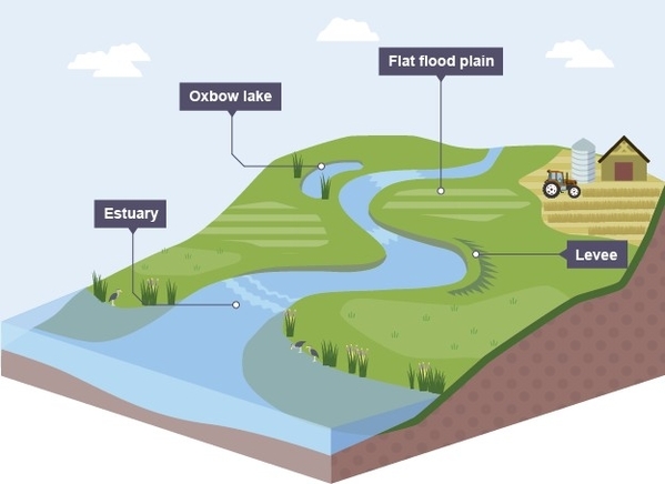
– The mouth is the place where a river ends, usually in a lowland area. It can be a lake, a sea, or an ocean. The mouth can also form a delta or an estuary, where fresh water mixes with salt water.
– The channel is the path that the river follows. It can be straight, curved, or braided. The channel is shaped by the flow of water and the erosion and deposition of sediments.
– The banks are the sides of the channel. They can be steep or gentle, depending on the slope of the land and the erosion and deposition of sediments. The banks can also be reinforced by vegetation, rocks, or human-made structures.
– The bed is the bottom of the channel. It can be rocky, sandy, muddy, or gravelly, depending on the type and size of sediments. The bed can also be smooth or rough, depending on the flow of water and the erosion and deposition of sediments.
– The tributaries are the smaller streams or rivers that join the main river. They increase the volume and the drainage area of the river. They can also affect the water quality and the biodiversity of the river.
– The meanders are the bends or curves in the channel. They are formed by the lateral erosion and deposition of sediments. They can also create oxbow lakes, which are crescent-shaped bodies of water that are cut off from the main channel.
– The rapids are the sections of the channel where the water flows faster and more turbulently. They are formed by the steep gradient or the uneven bed of the river. They can also create waterfalls, which are vertical drops of water over a ledge or a cliff.
– The floodplains are the flat areas of land on either side of the channel that are periodically flooded by the river. They are formed by the accumulation of sediments during floods. They can